Pisac ruins: an Inca site guide
From Cusco: Sacred Valley Tour with Pisac and Ollantaytambo
What are the Pisac ruins?
Pisac is a large Inca complex spread across a ridge above the Sacred Valley, combining ceremonial temples, military fortifications, residential terraces, vast curved agricultural terracing, and one of the largest Inca cemeteries — hundreds of tombs cut into the opposite cliff. The Intihuatana temple sector, with its carved bedrock and fine stonework, is the highlight. Entry is by boleto turístico only.
A whole Inca world on a single ridge
Most visitors to Pisac come for the market and treat the ruins as an optional add-on. That gets it backwards. The archaeological park above the town is one of the most complete and varied Inca sites in the Sacred Valley — arguably more so than the better-known Ollantaytambo — because it bundles almost every type of Inca construction into one dramatic ridge: ceremonial temples, military strongpoints, residential clusters, sweeping agricultural terraces, irrigation channels, and an enormous cliff cemetery, all wired together by paths and tunnels. It is less a single monument than an entire Inca settlement frozen mid-life.
This guide is about the ruins themselves — what each part is, how it fits together, and how to walk it. If you want the practical day-trip logistics of combining the site with the famous market, the Pisac market and ruins guide covers transport, timing, and prices. Here we go up the hill and stay there.
Who built it, and when
Pisac was built at the height of Inca power in the 15th century, most likely under Pachacuti, the emperor who transformed Cusco from a regional power into the capital of an empire and who is credited with Machu Picchu and much of the Sacred Valley’s monumental building. The site guarded the eastern approach to the Sacred Valley and the route toward the jungle frontier, which is why it carries so much military architecture alongside its ceremonial and agricultural functions.
It was never a single-purpose place. The Inca state typically combined defence, ritual, administration, and farming in one estate, and Pisac is a textbook example. After the Spanish conquest in the 1530s the complex was abandoned, the population eventually drifting down to found the colonial town on the valley floor, leaving the ridge to the weather and, much later, the tourists. For the wider context of how sites like this functioned, the Inca empire for travelers guide is a useful primer.
The sectors, from top to bottom
Pisac is usually walked downhill from the upper vehicle gate, so this is the order most visitors meet the site in.
The upper military and ceremonial sectors
Arriving from the top, you first cross the higher reaches of the ridge, where defensive walls, watchpoints, and a series of buildings command long views down both the Sacred Valley and the gorge below. This was the strategic crown of the site — the part that controlled who came up the valley. The architecture here is functional rather than fine: solid fieldstone walls, gateways, and the bones of guard structures.
The Intihuatana — the sacred core
The undisputed highlight is the Intihuatana sector, a tight, walled cluster of buildings perched on the ridge. Here the stonework changes completely: instead of rough fieldstone you get the fine ashlar masonry — precisely cut blocks fitted without mortar — that the Inca reserved for their most sacred structures, the same quality you see at Qorikancha in Cusco. At its centre is the carved bedrock outcrop that gives the sector its name: Intihuatana, loosely “the hitching post of the sun,” a sculpted stone thought to have served astronomical and ceremonial purposes, marking solstices and anchoring ritual.
Around it are ritual baths fed by Inca water channels that still run, a probable temple to the sun, and other ceremonial buildings. Take your time here — this is the densest, finest, and most rewarding part of Pisac, and it is easy to walk through too fast on the way down to the market.
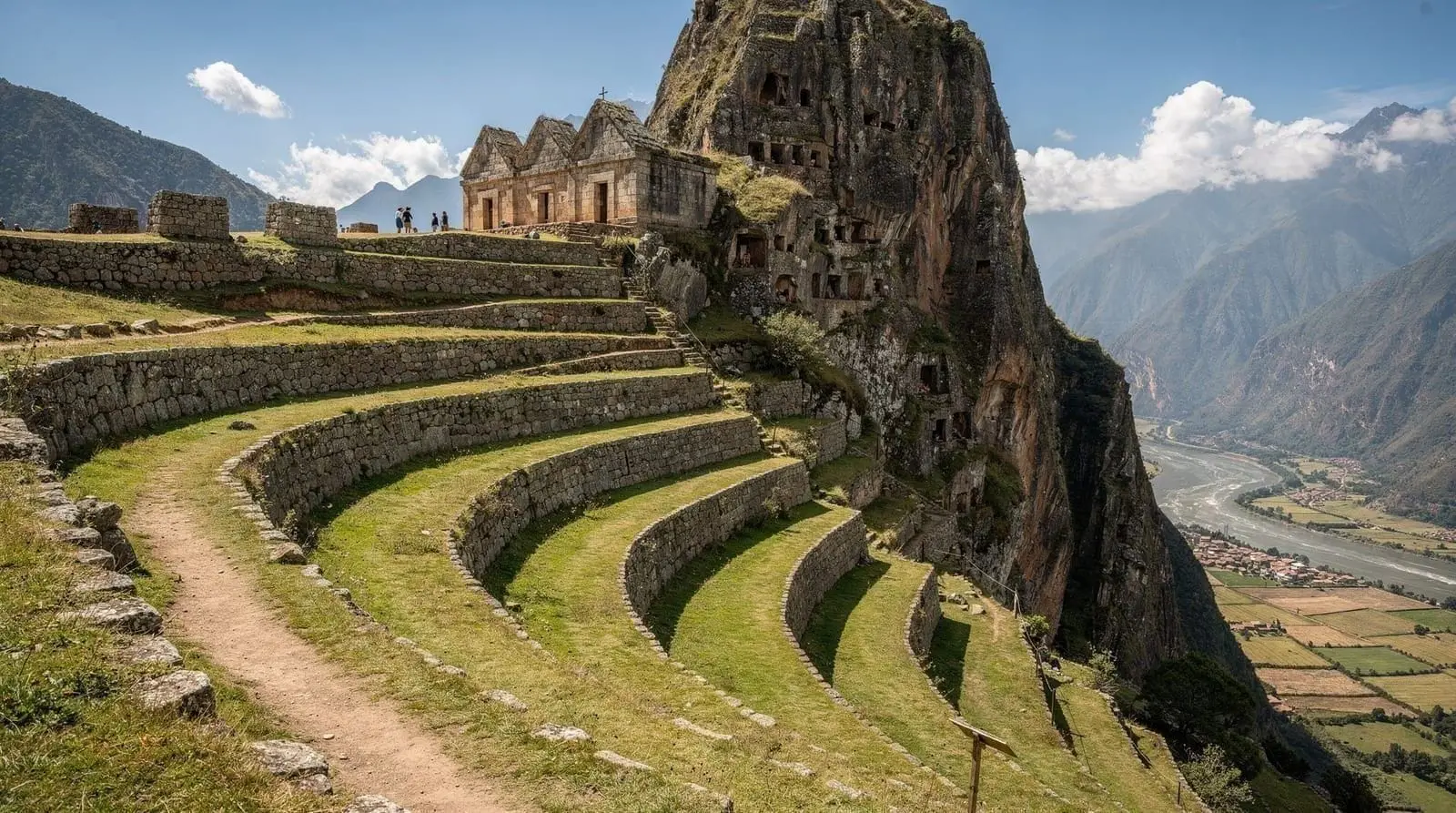
The agricultural terraces
Below and around the temples spill the andenes — the great curving agricultural terraces that fan across the steep slopes in broad arcs, following the contours of the ridge rather than imposing straight lines on it. They are both practical and beautiful: stone retaining walls hold flat strips of soil that turned a near-vertical mountainside into farmable land, with built-in drainage and microclimates that let the Inca grow crops at different altitudes. From across the valley they read almost as land art. They were the economic engine of the site, feeding its garrison and ceremonial functions.
The cliff cemetery
Look across the gorge from the ruins and you will see the opposite cliff face pocked with hundreds of small openings. These are Inca tombs — one of the largest known cemeteries of the empire. The dead were placed in a foetal position in niches cut and built into the rock. Virtually all were looted, many in the colonial and early modern periods, and the cliff is not accessible to visitors, but the sheer number of tombs visible from across the gorge is one of Pisac’s most striking and most overlooked sights. It is easy to walk past it without realising what you are looking at.
Residential clusters and the descent
Between these major sectors are residential and storage buildings, narrow paths, stairways, and at least one short rock tunnel that the route passes through. As you descend toward the lower terraces, the trail eventually links to the footpath that drops all the way to the modern town — a steep but scenic finish for those who want to end on foot rather than by taxi.
A practical walking route
The path of least resistance, and the one most visitors take:
- Taxi to the upper gate (“puerta de arriba”) from the town square — around S/25–40 for the car. This drops you at the top so you walk the whole site downhill.
- Start in the upper military sectors, taking in the long valley views.
- Slow right down at the Intihuatana — this is where the time is best spent.
- Walk through the terraces, looking back up at the temple complex and across at the cliff tombs.
- Continue down to the lower gate, or pick up the footpath all the way into town if your knees are willing.
Budget 1.5 to 2.5 hours for a relaxed downhill circuit. If you walk up from town first, add another 60–90 minutes of steep climbing — feasible but tough at 3,000-plus metres, and most people sensibly skip it.
A word on scale and signage: Pisac is much larger and more spread out than photos suggest, and it has almost no interpretive signage. Without context, the sectors blur into “more Inca walls.” Either hire a guide at the gate, join a guided Sacred Valley tour, or read up beforehand so you can tell the sacred temple core from the grain stores.
Tickets and practicalities
Entry is by boleto turístico only — there is no ruins-only ticket sold at the gate. The full 10-day boleto is S/130 (about USD 35) and a partial Sacred Valley circuit is S/70. Which to buy depends on the rest of your trip; the boleto turístico explained guide breaks it down, and the broader Cusco archaeological sites guide maps how Pisac fits alongside the other boleto sites.
The site is exposed and high — strong sun, thin air, and no shade up top. Bring water, a hat, sunscreen, and grippy shoes for the uneven, sometimes slick stone steps. Go early (gates open around 7am) to walk in cool air and beat the tour buses that arrive mid-morning.
Seeing it with a guide or as part of the valley
Because Pisac rewards context so heavily, a guided visit is worth considering — and most guided Sacred Valley itineraries include it as the first stop of the day. The Sacred Valley tour with Pisac and Ollantaytambo pairs Pisac’s spread-out ridge with Ollantaytambo’s vertical fortress, the two best ruins in the valley, with a guide to explain both. For a fuller day, the Pisac, Maras, Moray and Ollantaytambo small-group tour folds in the Maras salt terraces and Moray’s circular agricultural laboratory. Independent visitors can compare Pisac directly with the valley’s other great site in the Ollantaytambo ruins guide, and find multi-day routings at /itineraries/.
How Pisac compares to the other Sacred Valley sites
It helps to know where Pisac sits among the valley’s ruins, because most visitors see more than one and the sites are easy to blur together.
- Pisac vs Ollantaytambo. These are the two great ruins of the valley and the inevitable comparison. Ollantaytambo is concentrated and vertical — a steep terraced fortress-temple rising directly above a living town laid out on the original Inca street grid, with the monumental, unfinished Temple of the Sun and its colossal pink-granite blocks at the top. Pisac is spread out and varied, a whole settlement strung along a ridge with temples, fortifications, terraces, and the cemetery. If you want one sentence: Ollantaytambo impresses with scale and engineering, Pisac with breadth and atmosphere. Seeing both, as most Sacred Valley days do, is the ideal.
- Pisac vs Moray. Moray is the strange, beautiful complex of concentric circular terraces, widely read as an Inca agricultural experiment station. It is a single striking feature rather than a town; Pisac is far larger and more varied. They complement each other well on the same day.
- Pisac vs the city ruins. Up in Cusco, Sacsayhuamán shows the empire’s most monstrous megalithic stonework and Qorikancha its finest temple masonry. Pisac shows how all of those elements — defence, ceremony, agriculture, burial — combined in one working estate out in the provinces.
The practical upshot: do not treat Pisac as interchangeable with the other sites. It is the most complete of them, the one that best shows an entire Inca settlement at once, and it deserves real time rather than a rushed half-hour on the way to the market.
A note on the views and the photography
Beyond the archaeology, Pisac is one of the most photogenic Inca sites in Peru, and worth a word for that alone. The site’s position on a sharp ridge gives long views in two directions — down the green floor of the Sacred Valley with the Vilcanota river winding through it, and up the wild gorge toward the high mountains. The curving agricultural terraces, seen from above with the morning light raking across them, are the classic shot. The cliff cemetery across the gorge photographs well with a zoom. Go early not only for cooler air and thinner crowds but for the soft morning light, which is far kinder to the terraces and the valley than the flat, harsh glare of midday. Afternoon clouds can also roll up the valley in the wet season, swallowing the views entirely, so an early start hedges against that too.
Frequently asked questions about Pisac ruins: an Inca site
How old are the Pisac ruins?
What is the Intihuatana at Pisac?
What are the holes in the cliff at Pisac?
How long does it take to walk the Pisac ruins?
Do you need a guide for the Pisac ruins?
Are the Pisac ruins better than Ollantaytambo?
Top experiences
Bookable activities with verified prices and instant confirmation on GetYourGuide.

