Cumbemayo guide
Cajamarca: Explore the Cumbemayo Archaeological Complex
What is Cumbemayo?
Cumbemayo is a pre-Inca archaeological site 20 km from Cajamarca, famous for a canal carved into solid rock around 1500 BCE — one of the oldest engineered structures in the Americas — set among eroded volcanic pinnacles called frailones at about 3,500 m altitude.
Engineering older than the pyramids of Giza were ancient to the Inca
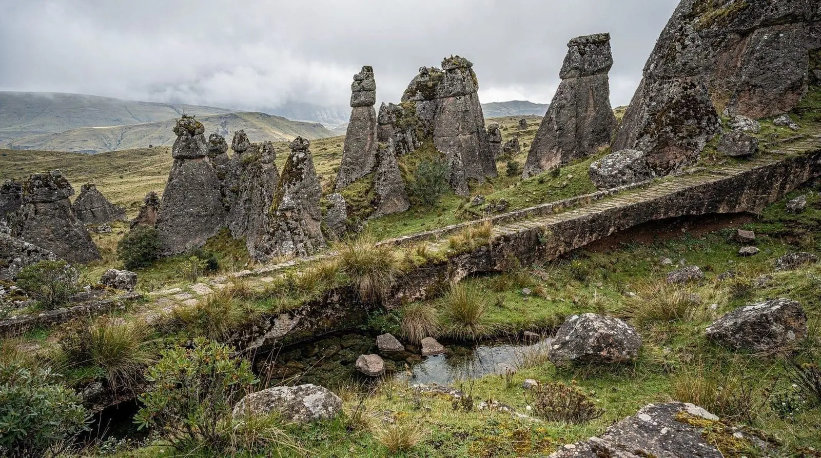
About 20 km southwest of Cajamarca, at 3,500 metres in the high páramo, a narrow channel runs through solid volcanic rock for more than eight kilometres. It is cut with right-angle turns, zig-zags that slow the water to prevent erosion, and a gradient so precise it still carries water today. This is the Cumbemayo aqueduct, carved around 1500 BCE — roughly 3,500 years ago, some three millennia before the Inca rose. It is one of the oldest engineered structures in the Americas, built by a pre-ceramic Andean culture whose name we do not even know, to channel water from the Atlantic-facing slopes across the continental divide toward the Pacific watershed and the Cajamarca valley.
Around the canal stands a second wonder, this one natural: the frailones, or “friars” — tall columns of eroded volcanic tuff that rise like hooded figures across the valley, forming a surreal stone forest. The combination of ancient hydraulic engineering and otherworldly rock formations, set in silent highland grassland with almost no other visitors, makes Cumbemayo the single most rewarding excursion from Cajamarca. This guide covers what you see, how to get there, the altitude, and how it fits a northern trip. The Cajamarca complete guide places it in the city’s two-to-three-day plan.
What you see at Cumbemayo
The site rewards an unhurried 1.5-to-2-hour walk. The highlights, roughly in the order most guided circuits take them:
The aqueduct (acueducto). The carved canal is the reason the site is protected. You walk alongside it, seeing the deliberate zig-zags engineered to dissipate the water’s energy and the meticulous channel cut directly into bedrock. That a pre-ceramic culture achieved this level of hydraulic control is genuinely staggering.
The frailones rock forest. Trails wind among the eroded pinnacles, and guides point out the formations locals have named for their resemblance to robed figures, animals and faces. The light and silence at altitude make this stretch the most atmospheric part of the visit.
The petroglyphs and the sanctuary. Near the canal’s head stands a large rock outcrop carved with petroglyphs and a small cave-sanctuary thought to have had ceremonial use. The engravings — abstract motifs and possible water symbolism — link the site’s spiritual and practical purposes.
Because the significance of a water channel and the meaning of the carvings are easy to miss alone, and because there is no public transport, almost everyone visits on a guided tour. The standard half-day excursion is:
Cajamarca: Explore the Cumbemayo Archaeological ComplexGetting there and what it costs
Cumbemayo is about 20 km southwest of Cajamarca, roughly an hour each way on a road that climbs steadily into the highlands. There is no scheduled public bus, so the practical options are a guided half-day tour or a hired taxi.
Site entrance is around S/8–12. A typical half-day group tour with transport and a Spanish-speaking guide runs S/40–70 (USD 11–19) per person; English-speaking guides cost more and should be arranged in advance through a Cajamarca agency or your hotel. A private taxi for the round trip with waiting time is S/80–120. Tours generally depart Cajamarca in the morning and return by early afternoon.
Hours at the site are typically daylight only, roughly 8am to 4pm, with morning visits preferred for clearer weather and softer light on the frailones. There are no significant services at the site beyond a small entrance area, so carry water, snacks, sun protection and a layer for the cool, exposed highland air.
The altitude — plan this excursion carefully
Cumbemayo’s 3,500 m is the highest point most visitors reach around Cajamarca, well above the city’s 2,750 m. The walk itself is gentle — mostly level with a few uneven sections — but the thin air makes even easy walking feel harder, and a brisk pace at this altitude can trigger headaches or breathlessness.
The single most important planning rule: do not visit Cumbemayo on the day you arrive in Cajamarca. Give yourself at least a day in the city first, then take the excursion on day two or three once your body has adjusted. Walk slowly, hydrate well, avoid alcohol the night before, and consider coca tea, which is widely available in Cajamarca and helps with mild altitude discomfort. Travellers who have been higher recently (in Cusco or Puno) will find Cumbemayo easy; those flying in straight from coastal Lima or Chiclayo should be more cautious.
Combining Cumbemayo with the rest of Cajamarca
Cumbemayo works as a self-contained half-day, which leaves the other half for the city or another excursion. A common rhythm: city and the Cuarto del Rescate on day one (to acclimatise gently), Cumbemayo on the morning of day two, then the Baños del Inca hot springs in the afternoon to soothe tired legs. The thermal-springs-and-dairy-farm tour pairs well as that afternoon counterpart:
Cajamarca: Hacienda La Colpa and Baños del Inca TourIf you would rather frontload the gentler sites while adjusting to the altitude, the city tour is the natural day-one option:
Cajamarca: City TourThe engineering, explained
It is worth pausing on why archaeologists make such a fuss about a ditch in the ground. The Cumbemayo canal runs for roughly eight kilometres and was cut entirely into solid volcanic bedrock using stone tools, by a culture that had not yet developed pottery. Its builders solved problems that still challenge engineers. The continental divide runs through here, so the canal had to capture water on the wetter eastern slopes and carry it westward toward the Cajamarca basin — a deliberate redirection of a watershed.
To stop the water from eroding its own channel, the builders engineered sharp right-angle turns and zig-zags at intervals, forcing the flow to slow and lose energy before it could scour the rock. The gradient was calculated with such accuracy that water still flows along surviving sections today, more than three millennia later. There are no inscriptions explaining who ordered the work or why, but the scale and precision imply an organised society with the authority to mobilise sustained labour and the accumulated knowledge to design a hydraulic system from scratch. That the result has outlasted the Inca, the Spanish empire and every state since is the quiet astonishment of the place.
Whether the canal was purely practical — irrigation and water supply — or also ceremonial is debated. The presence of carved petroglyphs and a rock sanctuary at the canal’s head suggests water here was sacred as well as useful, a combination common in Andean cultures where mountains and springs were revered as living powers.
How Cumbemayo fits a northern Peru trip
Cumbemayo is one of the strongest arguments for including Cajamarca on a northern itinerary at all. On a coast-to-highlands loop, you might see the Lord of Sipán and Túcume pyramids near Chiclayo, then cross the Andes to Cajamarca for the conquest history and Cumbemayo’s ancient engineering — a span of cultures from 1500 BCE to 1532 CE in a single region. The northern Peru route guide sequences these stops, and the north versus south Peru guide helps weigh the region against the busier Cusco circuit.
When to go and what to expect on arrival
Seasonally, the dry months from May to September are the most reliable window for Cumbemayo. The road and trails are firm, mornings are clear, and the light on the frailones is at its best. The wet season from December to March turns the highland landscape green and dramatic but brings muddier footing and more afternoon rain, and El Niño years can disrupt the road. February travellers should note that Cajamarca’s Carnival floods the city with visitors and waterfights, which is fun but books out hotels and tours — arrange your Cumbemayo excursion early if you come then.
On the day itself, most tours collect you from your hotel or a central meeting point mid-morning and drive about an hour into the highlands, gaining altitude steadily. At the site there is a small entrance area but few facilities, so use the bathroom and buy water before you leave the city. The guided walk loops through the canal, the frailones and the petroglyphs over 1.5 to 2 hours, and you are usually back in Cajamarca by early afternoon — leaving the rest of the day free for the Baños del Inca or the city. Tip your guide if the interpretation was good; it is customary and modestly paid work.
A note on photography: the frailones and the canal photograph beautifully in the clear morning light, far better than the harsh midday glare or afternoon haze, which is another reason to take the earliest tour you can.
Honest cautions
A few practical notes. First, respect the altitude timing — Cumbemayo on arrival day is the most common mistake travellers make in Cajamarca. Second, weather at 3,500 m is changeable: mornings are usually clear, but afternoon cloud, wind and cold roll in, so go early and bring a warm layer even in the dry season. Third, a guide genuinely matters here — the canal’s engineering and the petroglyphs are easy to walk past without explanation, so do not skip the guided tour to save a little money. Finally, wear proper shoes; some stretches around the rock formations are uneven and slick after rain.
Frequently asked questions about Cumbemayo
How old is the Cumbemayo aqueduct?
How high is Cumbemayo and is altitude a problem?
How do I get to Cumbemayo from Cajamarca?
How much does Cumbemayo cost?
What are the frailones at Cumbemayo?
How long does a Cumbemayo visit take?
Top experiences
Bookable activities with verified prices and instant confirmation on GetYourGuide.
